In April 2025, the first version of the mobile irrigation management app – PLAN was launched. At the time of release, Qiao and his team were working on an irrigation scheduling tool, specifically designed for producers who don't have access to soil moisture probes. This scheduling feature is now live and ready for use by all Nebraska producers. The following is a comprehensive, step-by-step guide to help producers navigate the new tool within the app.
Brief introduction: How it works:
This scheduler operates on a water balance model – imagine your soil as a bucket that expands as your crop grows. To prevent water stress, the tool maintains soil moisture depletion at no more than 40-50 percent of the bucket's capacity. The system estimates root development (which determines the soil "bucket" size) and calculates crop water use by determining crop coefficients based on days after planting (DAP) and reference evapotranspiration data from the nearest Nebraska Mesonet weather stations. The tool requires two key inputs: irrigation applications, which will need to be entered manually as they occur, and rainfall data, which is automatically retrieved from nearby Mesonet weather stations.
For producers in the Panhandle area who are already using the weekly crop water use information published by Gary et al., the key advantage of this scheduler is its ability to track daily crop water use specific to a field location, providing more precise and timely irrigation guidance.
Figure 1.
How to use it:
Step 1: Download the app from the iOS or Android app store. Note the app name has changed from PLAN to ACREE (Applied Collaborative Research, Extension & Education).
Figure 2.

Step 2: IMPORTANT - Register an account within the app, then email Dr. Xin Qiao (xin.qiao@unl.edu) with the field name and location to use with the scheduler. Currently, field setup must be completed manually through this process. An in-app field configuration will be available in future updates.
Step 3:
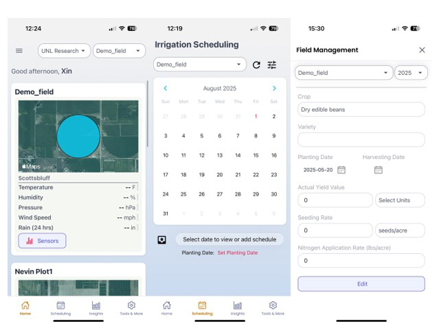
a. Once an account is set up and the field has been configured, the user should see their field listed on the home page (Figure 3a).
b. IMPORTANT: Navigate to the "Scheduling" tab, where there is a calendar but no graph initially (Figure 3b). Click "Set Planting Date," then enter both the crop type and planting date, and click Save (Figure 3c). While users can add additional information, the crop type and planting date are the minimum requirements for the scheduler to function. Currently, the supported crops are corn, dry bean, and sugar beets. Additional crops may be added in future updates based on user demand.
Figure 3
Step 4: Understanding the Soil Water Depletion Chart
Figure 4
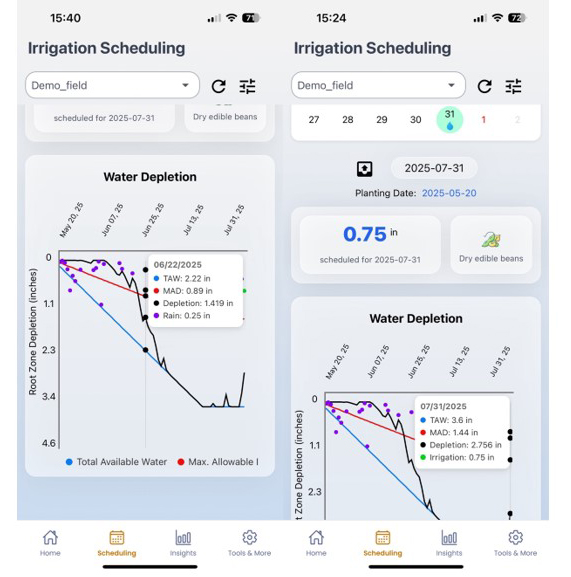
The 4th figure displays the root zone depletion chart, which contains three key lines:
- Blue line: Total available water (TAW) in inches, representing the total "bucket" size. This line grows as roots develop and plateaus when roots reach maximum depth.
- Red line: Maximum allowable depletion (MAD), indicating the threshold to avoid water stress.
- Black line: Actual soil water depletion, showing daily crop water use.
How the system works: The black line moves downward each day as crops use water, while irrigation or rainfall events recharge the soil and move the line upward. When the black line reaches zero, your soil is fully recharged and at field capacity.
Data inputs: The app automatically retrieves rainfall information from Mesonet weather stations, but you must manually enter irrigation amounts.
Adding an irrigation event:
1. Click on the desired date
2. Click the "+" sign beside that date
3. Enter the irrigation amount
4. Click anywhere on a blank area of the screen
5. Click "Save"
Once entered, a water icon will appear on that date. For example, Figure 4 shows 0.75 inches added to the Demo field on 7/31/2025 for dry beans.
Figure 5
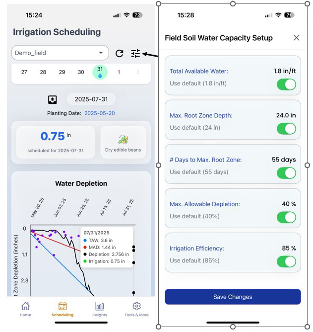
Fine-tuning the irrigation scheduler:
The app includes customizable settings that allow you to adjust the scheduler for your specific field conditions:
- Field capacity: Default is set to 1.8 inches per foot, but the user can adjust this value based on their soil type
- Maximum root zone depth: Customize based on crop and soil conditions
- Days to reach maximum root zone depth: Set the timeline for full root development
- Irrigation application efficiency: Default is 85 percent for center pivot systems, meaning that for every inch applied, 0.85 inches infiltrate into the soil
These settings can be modified to better reflect the producer’s fields' unique characteristics and irrigation system performance.
Important Disclaimer
Please note that this scheduler provides estimates of crop water use at the chosen field location and may not always be completely accurate. For example, if the field is located 20 miles from the nearest weather station, rainfall measurements may not accurately reflect conditions at the specific location. As Qiao’s team continues to improve the app, they welcome feedback. Please don't hesitate to contact them with any questions or comments about experiences using the scheduler.
Acknowledgement
We gratefully acknowledge the Nebraska Mesonet for providing essential weather data and ongoing support. We also thank our funding partners, including the Nebraska Dry Bean Commission and the National Science Foundation (Award Number 2420405), for their generous support that made this project possible.