The Gering/Ft. Laramie Irrigation District and the Goshen Irrigation District (Wyoming) held meetings July 24 to update stakeholders on progress toward restoring water flow in the Goshen/Gering Ft. Laramie Irrigation Canal. Early on July 17 a failure in a tunnel and canal bank near Ft. Laramie stopped irrigation water flow to approximately 107,000 acres in Wyoming and Nebraska.
Nebraska Extension provided the venue for the Gering-Fort Laramie Irrigation District meeting at the Panhandle Research and Extension Center in Scottsbluff, where approximately 250 attended. The University of Wyoming Extension/Eastern Wyoming College provided the venue for the Goshen Irrigation District meeting in Torrington, Wyoming, attended by approximately 300.
The majority of the audience were patrons of the irrigation district. Also attending both meetings were several dozen elected officials and local, state, and federal agency staff. They included county commissioners, state legislative representatives and aides, congressional aides, local USDA staff from the Farm Services Agency and Natural Resources Conservation Service, Farm Credit, and Nebraska and Wyoming Extension.
At the Scottsbluff meeting, the GFL Irrigation District General Manager updated the audience on the sequence of events that culminated in the canal breach. His voice breaking with emotion at times, Rick Preston described the irrigation boards’ urgent efforts since July 17 to assess the damage and seek solutions that might return the canal to service, both for this summer and for the long term.
The governors of Wyoming and Nebraska have issued emergency declarations to direct state resources to the area and are helping coordinate recovery efforts.
Finding a way to pay for the millions of dollars needed for repairs was a major topic of discussion at Scottsbluff. Potential federal, state, and local sources of funds were discussed.
Also discussed was whether federal crop insurance would cover any damage to crops caused by loss of water during a critical part of the growing season. There is no definitive answer, but several speakers said eligibility for crop insurance payments will depend on the determination of the cause of the canal break. Jessica Groskopf, Extension ag economist, is cautioning farmers to continue managing their crops as though they expect water to be returned to the canal to retain eligibility for crop insurance payments.
Xin Qiao, UNL irrigation and water management specialist at the Panhandle Center, provided data showing projected effects on crop yields if irrigation water is not available for several weeks. He is continuing to develop and refine the model. Deep-rooted sugar beets could be expected to survive longest, but all crops, including dry beans and corn, will suffer significant yield loss if water is not available soon.
Irrigation Boards Assessing Damage, Taking Steps to Restoration
Both irrigation district boards have been working since the tunnel collapse and canal break to develop a solution to restore water flow. Their original plan for a permanent repair fell through and now the plan is to install a temporary repair to get water flowing and continue with planning permanent repairs.
At the time of the tunnel collapse, the canal was flowing at approximately 1,325 cubic feet per second or 595,000 gallons of water per minute. It is estimated from the time of the tunnel collapse to the time the canal bank was breached was approximately six minutes. The canal breach not only eroded the canal bank but also the canal bed, up to 12 feet in some places. The water from the canal break damaged approximately 75 acres of corn on its way back to the river.

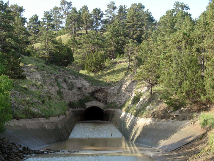
The entrance to the tunnel south of Fort Laramie, Wyo., where the July 17 collapse occurred. (Source: Gering-Fort Laramie Irrigation District)
Construction of the tunnel was completed in 1917. It is
- approximately 14 feet in diameter,
- 2,200 feet (0.42 miles) long with a drop or grade of approximately 2 feet for that length; and
- approximately 200 feet below ground at the entrance and 150 feet below at the exit.
The collapse occurred about 800 feet in from the tunnel entrance.
When the tunnel was dug, timber beams were used to support the tunnel walls. The concrete tunnel was then built inside the timber supports. This left a void between the outer portion of the concrete tunnel and the inner portion of the dug tunnel consisting of sandstone, Brule clay, sand, and the timber supports.
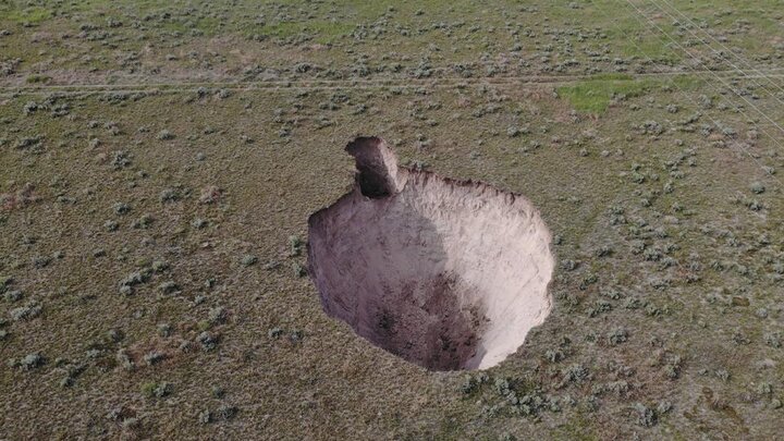
While it’s too early in the investigation to determine the cause of the tunnel collapse, some have suggested that over time, a large cavity may have formed over the tunnel. When the cavity could no longer support itself, it collapsed and broke through the concrete portion of the tunnel, causing the blockage and resulting breach of the canal bank. The estimate is that between 4,000 and 5,000 cubic yards of material fell through the tunnel break.
At this time the proposed fix for the tunnel is to work from both ends to clear out the material blocking the tunnel. When the safety contractor determines the need, spring steel supports or “stints” will be installed every four feet to support the tunnel from the inside. As this is being done, holes will be drilled in the original concrete tunnel at various points on the “clock,” for example at 7, 10, 2, and 4. A special grout mixture will be pumped into these holes until the mixture reaches 15 pounds of pressure. This special mix of concrete contains an additive that causes it to “foam” so that it will fill the void between the outer surface of the concrete tunnel and the inner surface of the natural tunnel as it hardens. This process is similar to the expanding foam used to seal leaks in a home's foundation. The grouting process will be done from the tunnel entrance to the tunnel exit. The extent of repairs at the collapse site will be determined when workers reach that point in the tunnel.
Contractors for the canal break have been on site repairing the canal bed and bank. The contractor for the tunnel work will be on site Friday, July 26. The hope is that work on both the tunnel and canal can be completed in 20 days.
How it Happened
The July 17 tunnel collapse occurred in a 2,200-foot-long tunnel along the main Gering/Ft. Laramie canal south of the town of Fort Laramie, Wyoming. The tunnel collapse caused water in the canal to back up and breach the canal bank, flooding the immediate vicinity.
The Bureau of Reclamation shut water off to the canal at Whalen Dam, the point where water is diverted from the North Platte River.
The canal failure halted water delivery to approximately 107,000 acres on the south side of the river in Scotts Bluff County, Nebraska, and Goshen County, Wyoming, areas served by the Gering-Fort Laramie and Goshen irrigation districts.
| To view key sites affected on Google Earth, search for these coordinates: | |
| Canal Break | 42.192122°, -104.507360° |
| Approximate Tunnel Collapse | 42.187010°, -104.49962° |
| Tunnel Entrance | 42.188976°, -104.500286° |
| Tunnel Exit | 42.183287°, -104.498447° |
For more information
Nebraska Extension and the University of Wyoming Extension are working together to share information and help growers in both states understand their options during this severe situation. A joint web page has been created at go.unl.edu/canal to provide information to stakeholders.
To learn more about the North Platte River and the irrigation projects in Nebraska and Wyoming, view the SlideShare presentation on the University of Nebraska Panhandle Research and Extension Center web site.


